Researchers and policy officials employ many definitions to distinguish rural from urban areas, which often leads to unnecessary confusion and unwanted mismatches in program eligibility. Whereas researchers often use the term rural when referring to nonmetro areas, and Congressional legislation uses the term when describing different targeting definitions, the U.S. Bureau of the Census provides an official, statistical definition that applies the term rural, based strictly on measures of housing unit and population density. The existence of multiple rural definitions reflects the reality that rural and urban can be distinguished using different geographic concepts and population thresholds. Sometimes population density is the defining concern, in other cases it is geographic isolation. Small population size typically characterizes a rural place, but how small is rural? Most population thresholds used to differentiate rural and urban communities range from 5,000 up to 50,000, depending on the definition.
Because the U.S. is a nation in which so many people live in areas that are not clearly rural or urban, seemingly small changes in the way rural areas are defined can have large impacts on who and what are considered rural. Researchers and policymakers share the task of choosing appropriately from among alternate rural definitions currently available or creating their own unique definitions. For instance, a housing assistance program may want to target remote or economically distressed rural communities, whereas programs designed to help rural businesses may want to expand target areas to include communities with greater access to urban markets.
Nonmetro Counties are Commonly Used to Depict Rural and Small-Town Trends
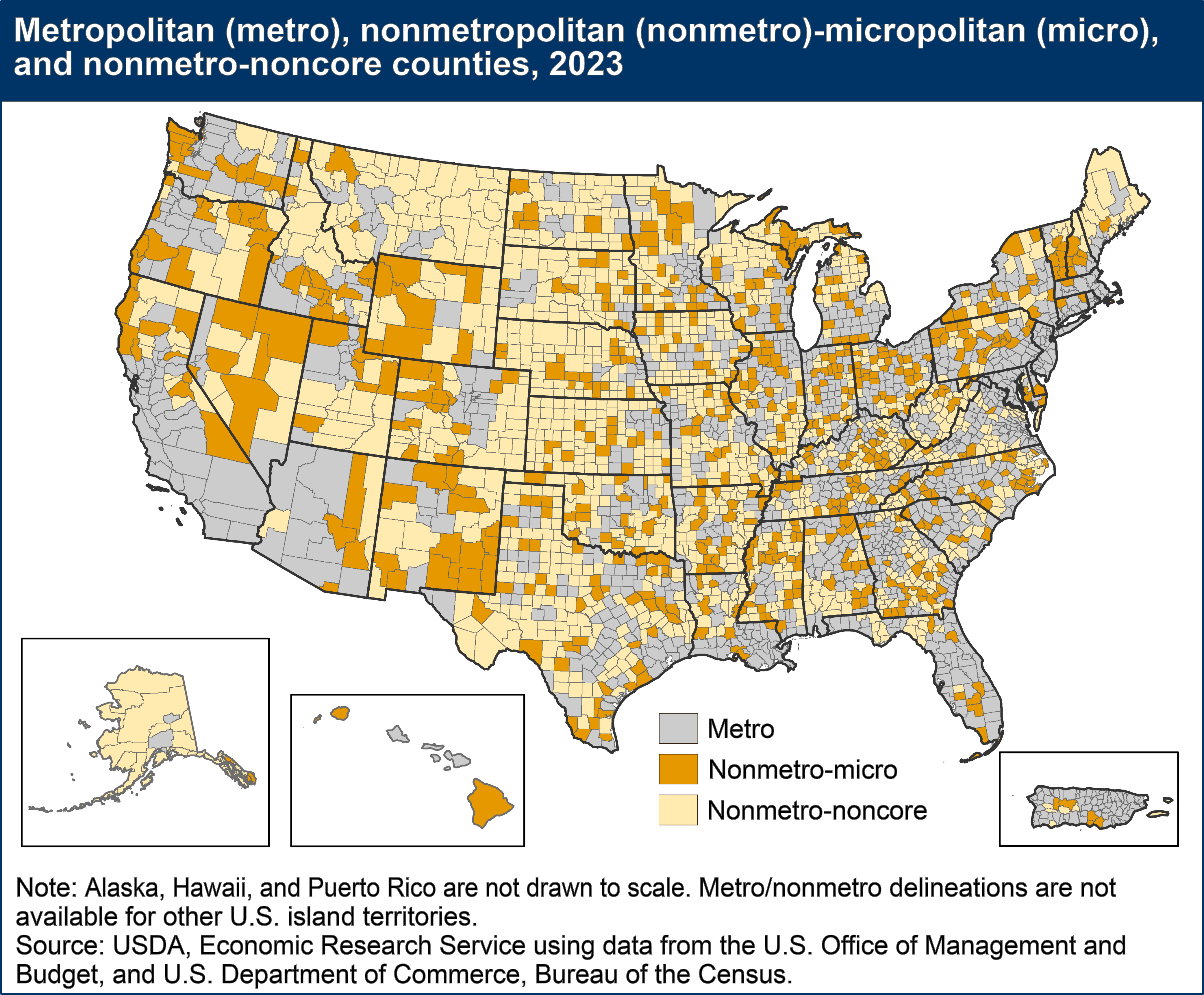
USDA, Economic Research Service (ERS) researchers and others who analyze conditions in "rural" America most often use data on nonmetropolitan (nonmetro) areas, defined by the U.S. Office of Management and Budget (OMB) on the basis of counties or county-equivalent units (e.g., parishes, boroughs). Counties are a standard unit for publishing economic data and for conducting research to track and explain regional population and economic trends. Estimates of population, employment, and income are available for counties annually. Counties also are frequently used as basic building blocks for areas of economic and social integration, such as labor-market areas.
A regional-economic concept underlies the formation of the metropolitan-nonmetropolitan classification. In 2023, OMB defined metropolitan (metro) areas as broad labor-market areas that include:
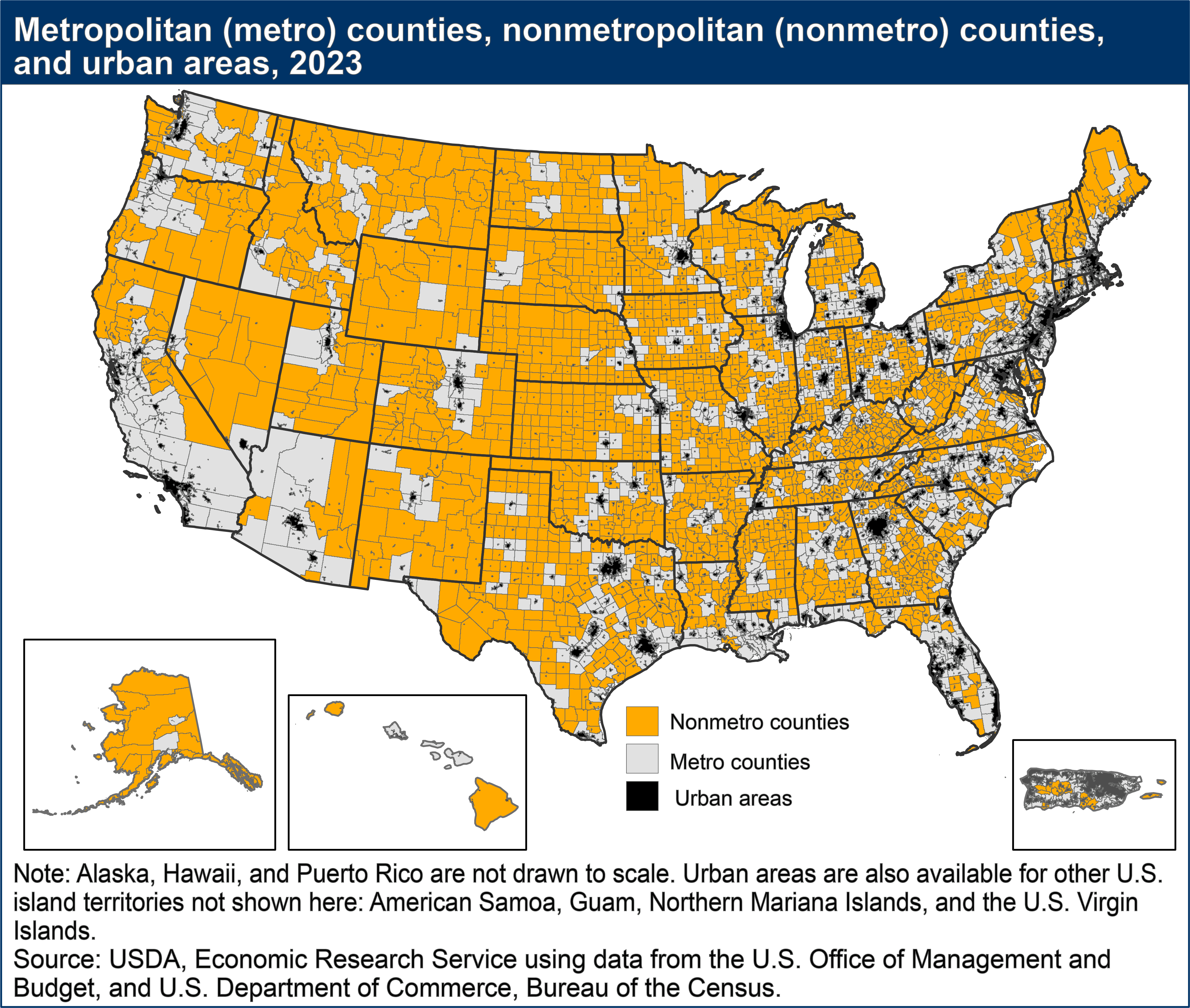
- Central counties with one or more urban areas with populations of 50,000 or more people. Urban areas, described in the next section, are densely-settled urban entities defined on the basis of population and housing-unit density.
- Outlying counties that are economically tied to the central counties as measured by labor-force commuting. Outlying counties are included if at least 25 percent of workers living in the county commute to the central counties, or if at least 25 percent of the employment in the county consists of workers coming out from the central counties—the so-called "reverse" commuting pattern.
Nonmetro counties are outside the boundaries of metro areas and are further subdivided into two types:
- Micropolitan (micro) areas, which are nonmetro labor-market areas centered on urban areas of 10,000-49,999 persons and defined with the same criteria used to define metro areas.
- All remaining counties, often labeled "noncore" counties because they are not part of "core-based" metro or micro areas.

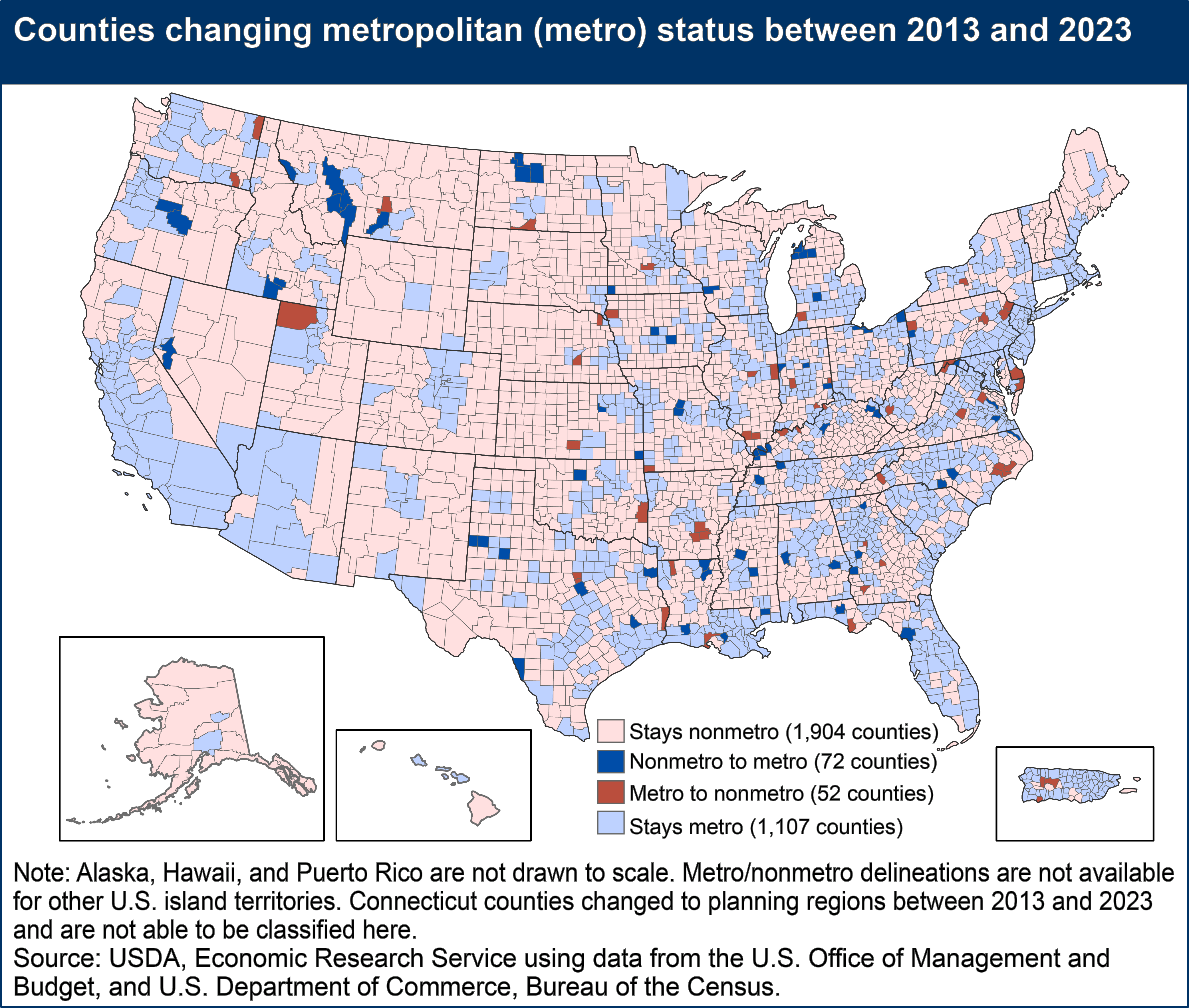
Every 10 years, following the decennial census, nonmetro counties that have been growing substantially enough or experiencing increasing commuting may be reclassified as metro. At the same time, some metro counties revert to nonmetro status, for instance when outlying counties experience shifts in commuting patterns. Changes in the criteria used to delineate urban and metro areas may also cause changes in metro-nonmetro status between decades.
In the latest decennial update announced by the U.S. Office of Management and Budget in July 2023, 72 nonmetro counties with 2,289,693 million people switched to metro status. At the same time, 52 metro counties with 2,059,223 residents switched to nonmetro status. The net loss for nonmetro areas because of reclassification (230,470 people) is by far the lowest for any decade since 1950, when metro areas were first delineated. It marks an historic downturn in urbanization during 2010–20 caused by a number of factors, including a much lower overall rate of growth for the United States and lower levels of suburbanization through much of the decade. However, a few changes in metro or nonmetro status resulted from new rules for defining urban areas, as described in the next section.

U.S. Bureau of the Census Defines Urban and Rural Areas on the Basis of Housing and Population Density
A very different definition of rural, based on much smaller geographic building blocks, is provided by the U.S. Bureau of the Census in its urban-rural classification system. Whereas researchers often use the term rural when referring to nonmetro areas, and Congressional legislation uses the term when describing different targeting definitions, the U.S. Bureau of the Census provides an official, statistical definition that applies the term rural, based strictly on measures of housing unit and population density. According to the current delineation, released in 2022 and based on the 2020 decennial census, rural areas comprise open country and settlements with fewer than 2,000 housing units and 5,000 residents. Urban areas comprise densely developed areas with 2,000 or more housing units or 5,000 or more residents. Urban areas do not necessarily follow municipal boundaries; they are essentially densely settled territory as it might appear from the air. Most counties, whether metro or nonmetro, contain a combination of urban and rural populations.

The U.S. Bureau of the Census defines urban areas primarily based on housing unit density measured at the census block level. In simplified terms, census blocks with 425 housing units per square mile form the initial core of urban agglomerations. Peripheral census blocks with 200 housing units per square mile are added to the core agglomeration. If the resulting urban entity contains at least 2,000 housing units or 5,000 people, it is designated an urban area. Several other factors are considered, for instance rules are added for the inclusion of noncontiguous territory separated by exempted territory (meaning it is not available for residential development). The term rural includes all population and territory outside urban areas.
The criteria now used to define urban areas represent a significant departure from previous decades. First, population density was the primary statistic used in the delineation of urban areas from 1960 to 2010. In general, urban areas had a core with a population density of 1,000 persons per square mile and included adjoining territory with at least 500 persons per square mile. In 2020, housing unit density replaced population density as the primary measure of designating census blocks as urban. Second, the minimum population size to qualify as an urban area was 2,500—a threshold that had been in place since 1910. As noted above, the minimum size for qualification in 2020 was 2,000 housing units or 5,000 people.
Because metro areas are built from urban areas, these two changes affected the delineation of metro and micro areas. A third change involved dropping a naming convention. From 2000 to 2020, urban areas had been divided into two types, urbanized areas with 50,000 or more people and urban clusters with 2,500 to 49,999 people. Now both types are referred to simply as urban areas. For more detail on current urban area criteria and on changes in criteria since 1950, see the Federal Register Notice: Urban Area Criteria for the 2020 Census-Final Criteria.
OMB "Nonmetro" and Census "Rural" Provide Different but Equally Useful Perspectives on Rural Populations
In 2020, 46 million people resided in OMB-defined nonmetro counties, making up 13.8 percent of the U.S. population. Census-defined rural areas included 66.3 million residents, or 20 percent of the population. Not only do they differ in terms of population share, these two classifications also identify two very different sets of people. The much lower minimum population threshold for urban areas (5,000 compared with 50,000 for metro areas) means that urban areas can be found in most nonmetro counties. At the same time, metro areas contain a significant portion of rural territory. Population statistics in the table show the extent of the difference in urban-rural and metro-nonmetro populations. For instance, the majority of rural residents (56 percent) live in metro counties. Also, 16.5 million nonmetro residents (36 percent) live in urban areas.
| Number of counties | Total population, 2020 | Urban population, 2020 | Rural population, 2020 | Percent urban | |
|---|---|---|---|---|---|
| Total | 3,143 | 331,449,281 | 265,149,027 | 66,300,254 | 80.0 |
| Nonmetro counties | 1,958 | 45,893,412 | 16,504,150 | 29,389,262 | 36.0 |
| Metro counties | 1,185 | 285,555,869 | 248,644,877 | 36,910,992 | 87.1 |
| Percent metro | 86.2 | 93.8 | 55.7 | ||
| Source:USDA, Economic Research Service using data from the U.S. Office of Management and Budget, and U.S. Department of Commerce, Bureau of the Census. |
|||||
The choice of a rural definition should be based on the purpose of the application, whether that application is for research, policy analysis, or program implementation. For instance, tracking urbanization and its influence on farmland prices is best approached using the Census urban-rural definition because what is needed is a land-use definition that distinguishes built-up territory from immediately surrounding, less developed land. Studies designed to track and explain economic and social changes often choose to use the metro-nonmetro classification, because it reflects a regional, labor-market concept and allows the use of widely available county-level data. The key is to use a rural-urban definition that best fits the needs of a specific research or policy making endeavor, recognizing that any simple dichotomy hides a complex rural-urban continuum, often with very gentle gradations from one level to the next. For a detailed comparison of economic, land-use, and administrative concepts underlying different rural definitions, see Defining the "Rural" in Rural America, Amber Waves, June 2008. For more detail on the pros and cons of the two definitions described above, and for descriptions of other rural definitions, see the Rural Definitions and Measurement tool in the FCSM Equitable Data Toolkit at Federal Committee on Statistical Methodology (FCSM) Equitable Data Toolkit Rural Definitions and Measures Tools.
Data Sources
- U.S. Office of Management and Budget, 2020 Standards for Delineating Core Based Statistical Areas
- U.S. Census Bureau, Core Based Statistical Area Delineation Files, July 2023
- U.S. Census Bureau, Metropolitan and Micropolitan Statistical Areas
- U.S. Census Bureau, Urban Area Criteria for the 2020 Census
- U.S. Census Bureau, Urban and Rural Classifications
